Download footpaths and map (PDF)
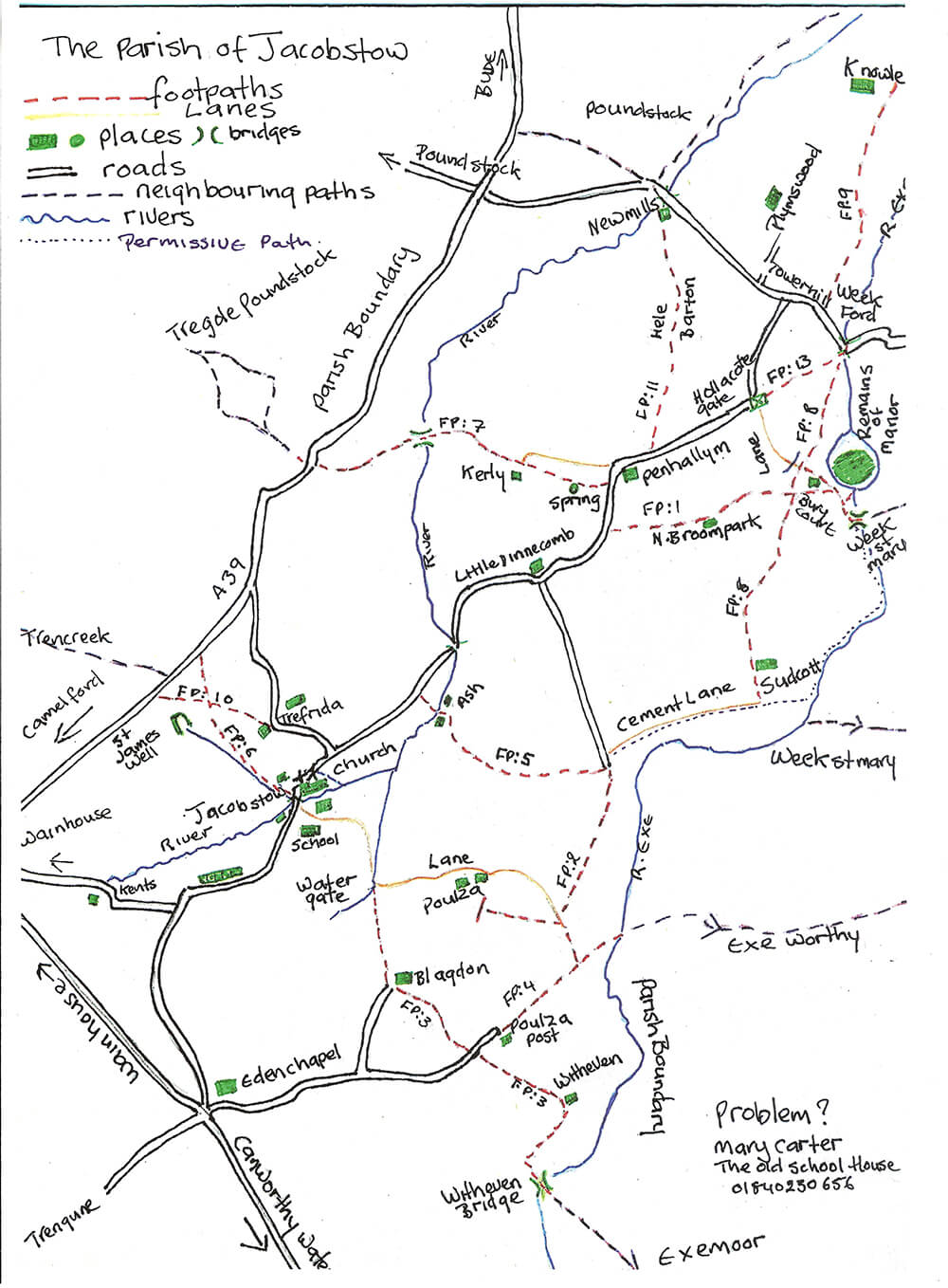
FP 6: Grid Ref: 198-959 to 193-963 From Jacobstow to road S of Highway
Take the path N of the church up the drive of the Rectory. On the left take the 1st kissing gate, following the advice given on the brass plates on each gate. Keep to the left of the field to go through the 2nd kissing gate and into the wood. After 3rd gate the path drops to follow the stream. The path bears right, NOT into the field directly opposite but through the 4th gate under a small copse. Keeping the hedge on your left, follow the edge of the field round to come to the last kissing gate to enter Witchy Pool Lane. A few yards up the lane FP 6 enters a field on the right and finishes on the A39. If you wish to visit the Holy Well of St James (grid ref SX192.962) which is on the Pilgrims route from Wales and Ireland to Compestella in Northern Spain, continue up the lane past a stand of stunted oaks, once part of a primeval forest. Soon the lane bears sharply right to a gate and stile leading to the A39. Ignor this and go through the gate on the left and into the field, this is by kind permission of the land owners. Bear left across the field to the small gated enclosure to find this special place.
FP 10: Grid Ref: 197-962 to 191-964 from Trefrida to Road A39 S of Highway
Take the lane leading North from Trefrida Farm, made up of cobbles taken by horse and cart from the beaches of Wanson Mouth and Millook. This is called Witchey Pool Lane. About 50 metres along the lane, just as the lane kinks left, there is the old site of the Ducking Pond. Continue along the lane to the A39.
FP 3: Grid Ref: 202-949 to 207-946 from Blagdon to West of Witheven Farm
Leaving the church on your left, take the first lane (School Lane) that leads east to Water Gate. If possible, go up the old sunken lane or follow the hedge (permissive path) to Blagdon. Until 1801 Blagdon was part of Penhallam Manor, circa 1201. Blakedon, circa 1600, Blakedon 1650, old English -nblacan-dun ‘dark hill/down’. Turn left at the farm house climbing over the stiles through 2 fields. At the 2nd stile, make a bee line for the kissing gate, through the gate, and over the next stile. Follow the hedge to the stile and Poulza Post-Eden Chapel Road. (For circular walk go to FP 4)
FP 12: Grid Ref: 211-939 to 207-947, Road junction West of Witheven to Witheven Bridge (Parish Boundary)
Take Witheven Lane past the cottage over the stile across the field to the pack bridge
FP 4: Grid Ref: 209-948 to 215-942 from East of Blagdon to Parish Boundary with spur to FP 2
Bearing NE to Poulza Post continue through the farm yard. Keep left over the stile and follow the hedge until one comes to a small copse with a high stile/step into field. The path goes straight across the field to the boundary in the direction of Exeworthy.
The path to NW continues the circular walk across the field to the gate and into the lane. FP4 continues to the left of Poulza, but as there is not a right of way through the farm yard, the path is not used, but the lane is permissible for a shorter walk back to the village. For the circular walk join FP 2.
FP 2: Grid Ref: 206-953 to 213-960 From Higher Poulza Farm to junction with FP 5
After a few yards down lane, enter the wood to the right. The path exits over a stile into a field, carry along the hedge to the end of the field and junction to FP 5. On the right is the road to Little Dinnicombe and the land to Sudcott.
FP 5: Grid Ref: 204-964 to 213-960 from W of Ash to junction with FP 2
Turn left on to what was once an 8ft cart track, over the stile into the copse keeping to the left, then across 2 open fields and then through the gate into Ash’s court yard. Follow the lane over the ford and up to the Jacobstow to Week St Mary Road.
FP 1: Grid Ref: 213-971 to 252-973 from road S of Penhallym to Parish Boundary (west wood common)
Take the lane to North Broom Park. Just before the farm enter the field in front of you, the 1st of 3, (This was once the track to Ashbury and Week St Mary) , until you arrive at the ford and junction for FP 8. FP 1 continues and bears right over a stile past Bury Court and the back entrance to the remains of a manor house, an English Heritage site. A few yards further on you cross Jacobstow's only listed bridge and the Parish boundary to meet Week St Mary path to Ashbury.
FP 8: Grid Ref: 221-963 to 220-978 from Sudcott to junction with FP 13 Harris Wood
From Sudcott the path leads down the track to the ford and the junction with FP 1, over the ford through the gate up the lane and take the path to the right to then join the lane through Harris Wood that ends at the Heritage site car park and Week Ford.
FP 13: Grid Ref:220-978 to 224-979 from road S of Plymswood to Week Ford
At Hollacote Gate at top of lane to Bury Court (which is where the rents were collected and misdemeanours judged). The path follows down through the forestry to Week Ford.
FP 7: Grid Ref: 198-974 to 293-976 from Penhallym to road S of South Penlean
Penhallym spelt with a ‘Y’ is the 2nd highest point in Cornwall, I’ve been told. According to ancient records this was the site of 36 households, a church, a foundry, blacksmith shop and manor. The views and a cottage is all that now remain. The stile for the path is in the hedge just south of the cottage, cross the field NW by the telegraph pole, over a stile in the hedge bear right NOT through the 1st gap, but follow the hedge round pass the site of a holy well to go through into a lane and over the stile by an oak to enter a small meadow to the next stile and to the back of Kerly, once a shop. Go down the lane beside the garden hedge over the stile and into a sunken lane. Cross the fields bearing W to descend into the valley. Look for the large wooden foot bridge that crosses the river (which starts just behind Kents and joins the River Neet that flows out of Bude). Follow the path past the pheasant pens to climb up the side of the valley to reach the A39.
FP 11: Grid Ref: 216-988 to 215-975 road N of Penhallyn to Newmills
Take the stile to cross 3 fields to arrive in the lane at the side of Hele Barton. Go past the holiday cottages heading N through a gate down the sunken lane that sometimes can be so wet that it is necessary to walk outside the hedge. Continue past the oaks to find at the bottom of a very large oak tree, home to a colony of wild bees. Opposite the stile, using the little bridges to pass an old homestead (Mary Spry’s birth place) and New Mills.
FP9: Grid Ref: 221-963 to 221-963 from Tower Hill to Parish Boundary (Knowl)
Follow the track to arrive at the Parish Boundary, where once there was a gate that swung into the 3 parishes of Week St Mary, Poundstock and Jacobstow.